


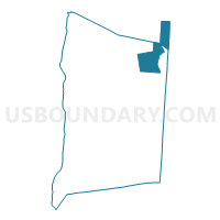
Voting District 110002, Dutchess County, New York
About
Outline

Summary
| Unique Area Identifier | 626403 |
| Name | Voting District 110002 |
| County | Dutchess County |
| State | New York |
| Area (square miles) | 33.70 |
| Land Area (square miles) | 33.36 |
| Water Area (square miles) | 0.34 |
| % of Land Area | 99.00 |
| % of Water Area | 1.00 |
| Latitude of the Internal Point | 41.94584250 |
| Longtitude of the Internal Point | -73.54663020 |
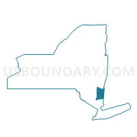
Maps

Graphs
Select a template below for downloading or customizing gragh for Voting District 110002, Dutchess County, New York


Neighbors
Neighoring Voting District (by Name) Neighboring Voting District on the Map
- Voting District 010001, Dutchess County, NY
- Voting District 010002, Columbia County, NY
- Voting District 010004, Dutchess County, NY
- Voting District 110001, Dutchess County, NY
- Voting District 130002, Dutchess County, NY
- Voting District 190001, Dutchess County, NY
- Voting District 190003, Dutchess County, NY
- Mount Washington Precinct 1, Berkshire County, MA
- Salisbury 1 Voting District, Litchfield County, CT
Top 10 Neighboring County Subdivision (by Population) Neighboring County Subdivision on the Map
- Amenia town, Dutchess County, NY (4,436)
- Stanford town, Dutchess County, NY (3,823)
- Salisbury town, Litchfield County, CT (3,741)
- North East town, Dutchess County, NY (3,031)
- Pine Plains town, Dutchess County, NY (2,473)
- Ancram town, Columbia County, NY (1,573)
- Mount Washington town, Berkshire County, MA (167)
Top 10 Neighboring Place (by Population) Neighboring Place on the Map
Top 10 Neighboring Elementary School District (by Population) Neighboring Elementary School District on the Map
Top 10 Neighboring Secondary School District (by Population) Neighboring Secondary School District on the Map
Top 10 Neighboring Unified School District (by Population) Neighboring Unified School District on the Map
- Taconic Hills Central School District, NY (12,275)
- Pine Plains Central School District, NY (9,080)
- Southern Berkshire School District, MA (7,613)
- Northeast Central School District, NY (6,750)
Top 10 Neighboring State Legislative District Lower Chamber (by Population) Neighboring State Legislative District Lower Chamber on the Map
- Assembly District 103, NY (134,686)
- Fourth Berkshire District, MA (37,775)
- State House District 64, CT (23,750)
Top 10 Neighboring State Legislative District Upper Chamber (by Population) Neighboring State Legislative District Upper Chamber on the Map
- State Senate District 41, NY (316,491)
- State Senate District 40, NY (316,324)
- Berkshire, Hampshire & Franklin District, MA (149,418)
- State Senate District 30, CT (102,325)
Top 10 Neighboring 111th Congressional District (by Population) Neighboring 111th Congressional District on the Map
- Congressional District 5, CT (714,296)
- Congressional District 20, NY (683,198)
- Congressional District 1, MA (644,956)
Top 10 Neighboring Census Tract (by Population) Neighboring Census Tract on the Map
- Census Tract 100, Dutchess County, NY (4,436)
- Census Tract 1700, Dutchess County, NY (3,823)
- Census Tract 2611, Litchfield County, CT (3,741)
- Census Tract 1000, Dutchess County, NY (3,031)
- Census Tract 1200, Dutchess County, NY (2,473)
- Census Tract 9343, Berkshire County, MA (1,886)
- Census Tract 17, Columbia County, NY (1,573)
Top 10 Neighboring 5-Digit ZIP Code Tabulation Area (by Population) Neighboring 5-Digit ZIP Code Tabulation Area on the Map
- 12546, NY (3,039)
- 12567, NY (2,854)
- 12501, NY (2,457)
- 06039, CT (1,942)
- 06068, CT (1,612)
- 01258, MA (374)